
- Home
- Holidays & Day Excursions ▼
- Day Excursions
- UK Holidays
- All UK Holidays
- England
- Wales
- Scotland
- Ireland
- London
- London Theatre Breaks
- Channel Islands
- Warner Leisure Breaks
- Short Breaks
- Festive Breaks
- Christmas & New Year
- Themed Breaks
- February Departures
- March Departures
- April Departures
- May Departures
- June Departures
- July Departures
- August Departures
- September Departures
- October Departures
- November Departures
- December Departures
- European Holidays
- Festive Breaks
- London Breaks
- Channel Island Holidays
- Our Fleet ▼
- Coach Hire
- Contact Us ▼
- Book a MOT
- School Services ▼
Cotswolds Tour
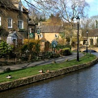
The Cotswolds is a rural area of south central England covering parts of 6 counties, notably Gloucestershire and Oxfordshire. Its rolling hills and grassland harbour thatched medieval villages, churches and stately homes built of distinctive local yellow limestone. The 102-mile Cotswold Way walking trail follows the Cotswold Edge escarpment from Bath in the south to Chipping Campden in the north.
The Cotswolds is a rural area of south central England covering parts of 6 counties, notably Gloucestershire and Oxfordshire. Its rolling hills and grassland harbour thatched medieval villages, churches and stately homes built of distinctive local yellow limestone. The 102-mile Cotswold Way walking trail follows the Cotswold Edge escarpment from Bath in the south to Chipping Campden in the north.
The Cotswolds is a rural area of south central England covering parts of 6 counties, notably Gloucestershire and Oxfordshire. Its rolling hills and grassland harbour thatched medieval villages, churches and stately homes built of distinctive local yellow limestone. The 102-mile Cotswold Way walking trail follows the Cotswold Edge escarpment from Bath in the south to Chipping Campden in the north.
Below is a list of pick-up points available on this tour.
Below is a list of pick-up points available on this tour.

| Name | Address |
|---|---|
| Hodthorpe WMC | Hodthorpe, The Working Mens Club |
| Langwith, The Gate Hotel | Langwith, The Gate Hotel |
| Mansfield, Walkden Street | Mansfield, Layby Opp Walkden St Car Park Entrance |
| Shirebrook, Ashbourne St | Shirebrook, Ashbourne Street, Opposite Ashbourne Court |
| The Sidings | The Sidings, Mansfield Woodhouse Off Debdale Lane |
| Warsop Library, High St | Warsop Library, Bus Stop, High Street |
| Whitwell Square | Whitwell Square |
| Worksop, Johnsons Depot | Worksop, Johnsons Depot, Dukeries Industrial Est |

